
1931 Map of Gould City NW
USGS Topo · Published 1931About this map
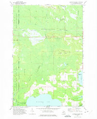
Manistique Lake and Whitefish Lake dominate the western landscape of this Upper Peninsula survey, conducted in the early 1930s. The region shows a transition from water-based commerce and settlement to an economy driven by timber and early motoring. A prominent Logging RR winds through the wetlands, illustrating the active lumber industry that defined the era, while State Highway No 135 provides a modern corridor through the center of the township. Local community life is anchored by small, isolated landmarks such as Sandtown Sch and the Sandtown Cem to the east, while the village of Curtis sits at the narrow isthmus between the two lakes. To the north, the boundary between Luce and Mackinac counties cuts through dense marshland, where sites like Camp 11 reflect the transient nature of regional work camps.
Find a feature on this map
14 named features on this map. Tap any name to fly to it.
Don’t see what you’re looking for? This feature index may not catch every label — zoom into the map to look around manually.
Map Details
Editions of this 1931 Gould City NW Map
This is the sole edition of this map. No revisions or reprints were ever made.
Other maps of this area

1931 · Gould City NE
USGS Topo · 1:31,680

1931 · Seney SE
USGS Topo · 1:31,680

1931 · Blaney NE
USGS Topo · 1:31,680

1931 · Gould City SE
USGS Topo · 1:31,680

1931 · Blaney SE
USGS Topo · 1:31,680

1954 · Sault Sainte Marie
USGS Topo · 1:250,000

1956 · Sault Sainte Marie
USGS Topo · 1:250,000

1957 · Sault Sainte Marie
USGS Topo · 1:250,000

1958 · Sault Sainte Marie
USGS Topo · 1:250,000
1972 · Hardwood Island
USGS Topo · 1:24,000