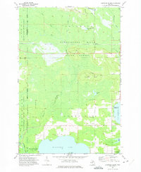
1972 Map of Hardwood Island
USGS Topo · Published 1975About this map
Manistique Lake and North Manistique Lake dominate the southern landscape of this 1970s survey, marking a significant hydrological divide where the Upper Peninsula’s waters flow toward both Lake Michigan and Lake Superior. The Soo Line railroad cuts a straight east-west path through the central forests, passing through the small settlement at Danaher and near the Danaher Plains. The terrain transitions from the low-lying wetlands of the Tahquamenon River and its branches in the north to the higher ground of Hardwood Island. Local history is preserved in the location of the West Lakefield Cem and Carpenter Landing on the eastern shore of the north lake. Numerous gravel pits scattered throughout the Lakefield and Columbus townships suggest the area's geological utility and the development of local infrastructure during this era.
Find a feature on this map
30 named features on this map. Tap any name to fly to it.
Don’t see what you’re looking for? This feature index may not catch every label — zoom into the map to look around manually.
Map Details
Editions of this 1972 Hardwood Island Map
2 editions found
Other maps of this area

1931 · Seney SW
USGS Topo · 1:31,680

1931 · Seney NW
USGS Topo · 1:31,680

1931 · Gould City NW
USGS Topo · 1:31,680

1931 · Seney SE
USGS Topo · 1:31,680

1931 · Blaney NE
USGS Topo · 1:31,680

1931 · Blaney NW
USGS Topo · 1:31,680

1954 · Sault Sainte Marie
USGS Topo · 1:250,000

1956 · Sault Sainte Marie
USGS Topo · 1:250,000

1957 · Sault Sainte Marie
USGS Topo · 1:250,000

1958 · Sault Sainte Marie
USGS Topo · 1:250,000