Old Maps of Seney Township, Michigan
Explore 91 old maps of Seney Township, spanning from 1931 to today. These high-resolution historic maps reveal how streets, neighborhoods, landmarks, and natural features evolved over time — perfect for genealogy, metal detecting, research, and local history exploration.
What you can do with these maps:
- See how Seney Township changed over time: Compare historical maps to modern-day views to trace roads, homesites, rail lines & more.
- View detailed metadata: Each map includes creators, publishers, year, scale, and archive source.
- Overlay maps with satellite & LiDAR: Visualize the past alongside modern tools to explore terrain & human change.
- Trusted historical sources: Maps sourced from the USGS, Library of Congress, and other archives.
- Access maps your way: View online, download high-res files, or order prints for personal or research use.
Start exploring old maps of Seney Township to uncover forgotten places, hidden landmarks, and the deep history beneath your feet.
Seney Township, MI maps
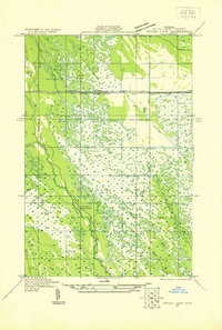
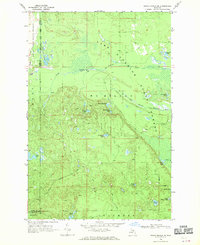
(91)- 1931 Map of Seney SW
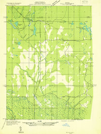
 1931 Seney SW1931 Print · USGSUpper Peninsula wetlands and rail corridors are preserved in this early 1930s survey of Schoolcraft County. Genealogists and historians can trace the foundations of Seney and Germfask along the Manistique River and the Duluth South Shore and Atlantic railroad.
 - 1931 Map of Seney NW
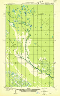
 1931 Seney NW1931 Print · USGSUpper Peninsula wetlands and timberlands are captured here in the early 1930s as State Highway 77 began to define regional travel. Researchers can trace the complex headwaters of the Tahquamenon Lakes and the isolated settlement at Lavender Corner.2 unique versions available
 - 1931 Map of Driggs Lake NE
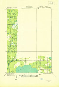
 1931 Driggs Lake NE1931 Print · USGSThe Upper Peninsula wilderness at the start of the 1930s is documented here through a network of lakes and winding river bends. Trace the early trails and water routes used by foresters and hunters, from the Fox River to the distinctive Little Devils Elbow.2 unique versions available
 - 1931 Map of Seney SE
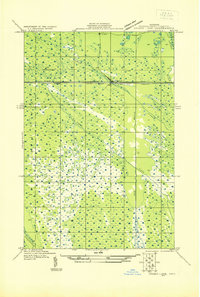
 1931 Seney SE1931 Print · USGSThe Upper Peninsula lake country at the start of the 1930s reveals a wilderness defined by its massive waterways and isolated settlements. Genealogists and researchers can trace the rail-and-road corridor of State Highway No 28 and the D S S and A near the Smithers Sch.
 - 1931 Map of Driggs Lake NW
 1931 Driggs Lake NW1931 Print · USGSUpper Peninsula wetlands and glacial lakes are documented in the early 1930s as aerial photography began to transform modern mapping. Researchers can trace the original courses of the Driggs River and Little Fox River or locate remote landmarks like Nevins Lake and Mahoney Creek.2 unique versions available
 - 1931 Map of Driggs Lake SW
 1931 Driggs Lake SW1931 Print · USGSUpper Peninsula wetlands and rail infrastructure are captured here in the early 1930s, showing the intersection of transport and terrain. Trace the early corridor of the Duluth South Shore and Atlantic railroad and the settlement of Walsh near the Driggs River.
 - 1931 Map of Driggs Lake SE
 1931 Driggs Lake SE1931 Print · USGSThe wetlands of the Seney area are captured here in the early 1930s, showing a landscape of remote camps and complex drainage. Genealogists and researchers can trace early transit routes like the Duluth South Shore and Atlantic railway and locate the isolated Cookson Camp.
 - 1954 Map of Sault Sainte Marie, 1979 Print
 1954 Sault Sainte Marie1979 Print · USGSThe Eastern Upper Peninsula and Ontario borderlands are captured here at the height of the mid-century era. Family historians can trace settlements like Grand Marais and Stalwart, while mapping the strategic grounds of Kincheloe AFB.3 unique versions available
 - 1956 Map of Sault Sainte Marie, 1964 Print
 1956 Sault Sainte Marie1964 Print · USGSThe Eastern Upper Peninsula and the Canadian border meet in this mid-sixties survey of the bustling Soo Locks region. Genealogists and historians can trace the paths of the Soo Line and locate lakeside communities from Grand Marais to Shelldrake.2 unique versions available
 - 1957 Map of Sault Sainte Marie
 1957 Sault Sainte Marie1957 Print · USGSThe Upper Peninsula and Ontario border come alive in this mid-century portrait of the eastern Lake Superior shoreline and the vital St. Marys River corridor. Genealogists and historians can trace rail-era settlements from Newberry to Detour, while locating military landmarks like Kinross Air Force Base.
 - 1958 Map of Sault Sainte Marie
 1958 Sault Sainte Marie1958 Print · USGSThe eastern Upper Peninsula and the Canadian borderland appear here during the late fifties, a time of military growth and forest management. Researchers can locate vanished rail stops along the Soo Line, early sites like the Fiborn Quarry, and the sprawling Kinross Air Force Base.
 - 1958 Map of Marquette, 1968 Print
 1958 Marquette1968 Print · USGSThe Upper Peninsula’s central corridor is captured here in the mid-twentieth century as mining and timber industries thrived alongside new military installations. Genealogists and historians can trace the rail lines of the Soo Line Railroad through settlements like Gwinn, Turin, and Chatham.2 unique versions available
 - 1960 Map of Marquette
 1960 Marquette1960 Print · USGSUpper Peninsula mining and maritime commerce reach their peak in the late fifties across the Lake Superior shoreline. Genealogists and historians can locate remote settlements like Big Bay and Dukes, while tracing the Cyr Mine and the active rail lines of the Lake Superior and Ishpeming railroad.
 - 1961 Map of Marquette
 1961 Marquette1961 Print · USGSUpper Peninsula life in the early sixties centered on the iron docks and timber stands of the Lake Superior shore. Genealogists and historians can trace rail-to-port connections via the Lake Superior and Ishpeming Railroad and locate active sites like Republic Mine or the K.I. Sawyer Air Force Base.
 - 1966 Map of Au Sable Point SE, 1968 Print
 1966 Au Sable Point SE1968 Print · USGSUpper Peninsula timberlands and glacial lakes are documented here in the mid-1960s as federal protection expanded. Researchers can trace the Old Railroad Grade and Adams Trail or locate remote sites like the Gypsy Lake Lookout Tower and Green Haven.2 unique versions available
 - 1966 Map of Au Sable Point SW, 1968 Print
 1966 Au Sable Point SW1968 Print · USGSThe Upper Peninsula wilderness of the mid-sixties is preserved here, showing the intersection of new conservation lands and traditional forest tracts. Researchers can trace historic routes like the Au Sable Point Trail across the Kingston Plains and locate dozens of named water bodies from Kingston Lake to Pelican Lake.2 unique versions available
 - 1968 Map of Nawakwa Lake, 1970 Print
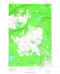
 1968 Nawakwa Lake1970 Print · USGSThe Upper Peninsula interior comes to life in the late 1960s, showing a vast wooded terrain punctuated by glacial lakes and old logging routes. You can trace the Old Railroad Grade or locate remote camps near Nawakwa Lake and Lavender Corner.
 - 1968 Map of Grand Marais SE, 1970 Print
 1968 Grand Marais SE1970 Print · USGSThe Upper Peninsula wilderness of the late sixties is mapped here along the shoreline of Lake Superior. Researchers can trace the winding paths of the North Branch Two Hearted River or locate remote landmarks like Dillingham Lake and Wheeler Lake.
 - 1968 Map of Marquette, 1977 Print
 1968 Marquette1977 Print · USGSThe Upper Peninsula iron range and Lake Superior coastline are captured here in the late sixties. Genealogists and historians can trace the rail-to-port infrastructure and the Cold War presence of K I Sawyer Air Force Base alongside towns like Ishpeming and Munising.
 - 1972 Map of Hardwood Island, 1975 Print
 1972 Hardwood Island1975 Print · USGSLuce and Schoolcraft counties are shown in the early 1970s, a landscape defined by the vast northern forests and the clear shores of the Manistique lakes. Genealogists and historians can locate the West Lakefield Cem, the Soo Line rail stops at Danaher, and the landings along North Manistique Lake.2 unique versions available
 - 1972 Map of Driggs Lake SE, 1975 Print
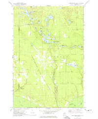
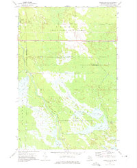 1972 Driggs Lake SE1975 Print · USGSSchoolcraft County’s managed wetlands and timberlands are captured here in the early 1970s. Trace the complex water diversions through the Seney National Wildlife Refuge and follow the route of the Soo Line across the Grand Sable State Forest.
 - 1972 Map of Walsh, 1975 Print
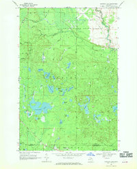
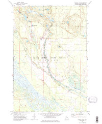
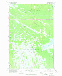 1972 Walsh1975 Print · USGSSchoolcraft County’s wild interior is captured here in the early seventies, where the massive Seney wetlands meet the state forest. Track the industrial footprint of the Soo Line railroad and discover managed water features like Pool C-3 and the Walsh Ditch.
 - 1972 Map of Seney, 1975 Print
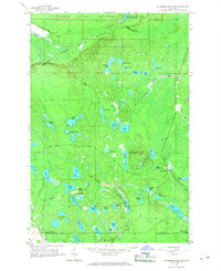
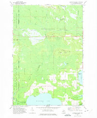
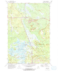 1972 Seney1975 Print · USGSThe Upper Peninsula marshlands are captured here in the early 1970s, showcasing the extensive water management systems of the Seney National Wildlife Refuge. Researchers can trace the legacy of regional transport through the SOO LINE railroad and the OLD RAILROAD GRADE near Seney.2 unique versions available
 - 1972 Map of Tahquamenon Lakes, 1975 Print
 1972 Tahquamenon Lakes1975 Print · USGSLuce County’s lake country is captured here in the early 1970s, showing a vast network of timber roads and forest lands. Researchers can trace the layout of the Laketon settlement and find numerous small water bodies like Camp 7 Lake and Fur Farm Lake.
 - 1972 Map of Sunken Lake, 1975 Print
 1972 Sunken Lake1975 Print · USGSThe Grand Sable State Forest in the early seventies shows a landscape defined by the winding Fox River and secluded glacial lakes. Researchers can locate remote sites like Fox River Campground, Sunken Lake, and the winding Little Fox River as they appeared before modern development.2 unique versions available
Showing maps 1-25 of 91
Top cities near Seney Township
Top neighborhoods of Seney Township
Frequently asked questions
- What are the different types of historical maps available for Seney Township?
- What is the oldest map of Seney Township?
- Where can I purchase historical maps of Seney Township for my home or office?
- Where can I download high-res historical maps of Seney Township?
- Are there historical topographic maps available for Seney Township?
- Is there historical aerial imagery available for Seney Township?
- Where are historical maps of Seney Township sourced from?