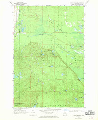
1968 Map of Grand Marais SE
USGS Topo · Published 1970About this map
Lake Superior defines the northern edge of this remote Upper Peninsula landscape, where the waters of the North Branch Two Hearted River and West Branch Two Hearted River wind through heavy timberlands. Recorded in the late 1960s, this area is primarily comprised of the Grand Sable State Forest and Lake Superior State Forest, spanning the borders of Alger, Luce, and Schoolcraft counties. The map reveals a dense network of inland waters including Dillingham Lake, Martindary Lake, and the Beavertown Lakes. Human presence is marked by a labyrinth of Jeep Trails and scattered Gravel Pits, indicating a landscape managed for resource extraction and forestry. The topography is dotted with family-named features like Potters Lake and Wheeler Lake, providing a detailed look at this wilderness before modern developments shifted the character of these state-managed forest lands.
Find a feature on this map
30 named features on this map. Tap any name to fly to it.
Don’t see what you’re looking for? This feature index may not catch every label — zoom into the map to look around manually.
Map Details
Editions of this 1968 Grand Marais SE Map
This is the sole edition of this map. No revisions or reprints were ever made.
Other maps of this area

1931 · Seney NW
USGS Topo · 1:31,680

1954 · Sault Sainte Marie
USGS Topo · 1:250,000

1956 · Sault Sainte Marie
USGS Topo · 1:250,000

1957 · Sault Sainte Marie
USGS Topo · 1:250,000

1958 · Sault Sainte Marie
USGS Topo · 1:250,000
1968 · Nawakwa Lake
USGS Topo · 1:24,000

1968 · Muskallonge Lake SW
USGS Topo · 1:24,000

1968 · Muskallonge Lake West
USGS Topo · 1:24,000
1968 · Grand Marais
USGS Topo · 1:24,000
1968 · Grand Marais NE
USGS Topo · 1:24,000