
1968 Map of Muskallonge Lake West
USGS Topo · Published 1970About this map
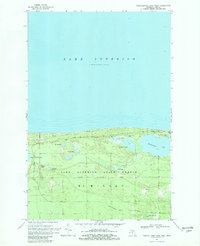
Lake Superior dominates the northern horizon of this coastal survey, where the shoreline of Michigan's Upper Peninsula meets the deep waters of the Great Lakes. The landscape is defined by the Lake Superior State Forest, a densely wooded expanse in McMillan township characterized by a complex network of wetlands and small inland bodies of water. The Blind Sucker River parallels the coast, feeding into the expansive Blind Sucker Flooding. This area serves as a primary recreational corridor, centered around Muskallonge Lake State Park and the large, prominent Muskallonge Lake. The map reveals the intricate drainage patterns of the region, where isolated waters like Rainy Lake, Snowplow Lake, and Holland Lake are connected only by seasonal paths and logging routes such as the Grand Marais Truck Trail.
Find a feature on this map
20 named features on this map. Tap any name to fly to it.
Don’t see what you’re looking for? This feature index may not catch every label — zoom into the map to look around manually.
Map Details
Editions of this 1968 Muskallonge Lake West Map
2 editions found
Other maps of this area

1954 · Sault Sainte Marie
USGS Topo · 1:250,000

1956 · Sault Sainte Marie
USGS Topo · 1:250,000

1957 · Sault Sainte Marie
USGS Topo · 1:250,000

1958 · Sault Sainte Marie
USGS Topo · 1:250,000

1968 · Muskallonge Lake East
USGS Topo · 1:24,000

1968 · Muskallonge Lake SW
USGS Topo · 1:24,000

1968 · Muskallonge Lake SE
USGS Topo · 1:24,000
1968 · Grand Marais SE
USGS Topo · 1:24,000
1968 · Grand Marais NE
USGS Topo · 1:24,000
1985 · Two Hearted River
USGS Topo · 1:100,000