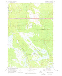
1972 Map of Driggs Lake SE
USGS Topo · Published 1975About this map
Seney National Wildlife Refuge and the Grand Sable State Forest dominate this Upper Peninsula landscape, where a sophisticated network of 20th-century water management features defines the wetlands. The terrain is crisscrossed by an extensive system of ditches and diversions, including the Holland Ditch, Twomlie Ditch, and Unit No 1 Diversion Ditch, which channel water through the marshlands and into various managed pools like C-3 Pool and Sweeney Pool.
Find a feature on this map
27 named features on this map. Tap any name to fly to it.
Don’t see what you’re looking for? This feature index may not catch every label — zoom into the map to look around manually.
Map Details
Editions of this 1972 Driggs Lake SE Map
This is the sole edition of this map. No revisions or reprints were ever made.
Other maps of this area

1931 · Seney SW
USGS Topo · 1:31,680

1931 · Seney NW
USGS Topo · 1:31,680

1931 · Manistique River NE
USGS Topo · 1:31,680

1931 · Driggs Lake NE
USGS Topo · 1:31,680

1931 · Manistique River NW
USGS Topo · 1:31,680

1931 · Driggs Lake NW
USGS Topo · 1:31,680

1931 · Driggs Lake SW
USGS Topo · 1:31,680

1931 · Blaney NW
USGS Topo · 1:31,680

1931 · Driggs Lake SE
USGS Topo · 1:31,680

1954 · Sault Sainte Marie
USGS Topo · 1:250,000