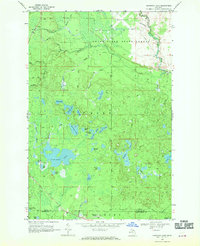
1968 Map of Nawakwa Lake
USGS Topo · Published 1970About this map
Grand Sable State Forest blankets this northern landscape, defined by a dense network of glacial kettle lakes and the meandering Sucker River. The interior of Burt and Seney townships is largely inaccessible except by an extensive system of Jeep Trails and a prominent Old Railroad Grade that cuts through the northern sections, tracing the legacy of earlier timber extraction. Nawakwa Lake serves as the central focal point, surrounded by smaller named bodies of water like Sullivan Lake, Mitchell Lake, and Newton Lake.
Find a feature on this map
47 named features on this map. Tap any name to fly to it.
Don’t see what you’re looking for? This feature index may not catch every label — zoom into the map to look around manually.
Map Details
Editions of this 1968 Nawakwa Lake Map
This is the sole edition of this map. No revisions or reprints were ever made.
Other maps of this area

1931 · Seney NW
USGS Topo · 1:31,680

1931 · Driggs Lake NE
USGS Topo · 1:31,680

1954 · Sault Sainte Marie
USGS Topo · 1:250,000

1956 · Sault Sainte Marie
USGS Topo · 1:250,000

1957 · Sault Sainte Marie
USGS Topo · 1:250,000

1958 · Sault Sainte Marie
USGS Topo · 1:250,000

1958 · Marquette
USGS Topo · 1:250,000

1960 · Marquette
USGS Topo · 1:250,000

1961 · Marquette
USGS Topo · 1:250,000

1966 · Au Sable Point SE
USGS Topo · 1:24,000