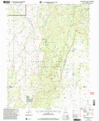
2002 Map of Government Point
USGS Topo · Published 2005About this map
Boulder Mountain dominates this high-altitude landscape within the Dixie National Forest, showcasing a complex network of alpine lakes and springs. The terrain is characterized by massive volcanic plateaus and basalt flows, where landmarks like Government Point and Lookout Peak rise above a series of named flats and coves. The hydrological pattern is remarkably dense for the region, featuring Alkali Lake, Pine Creek Reservoir, and the clusters of Snow Lakes and Bullberry Lakes.
Find a feature on this map
63 named features on this map. Tap any name to fly to it.
Don’t see what you’re looking for? This feature index may not catch every label — zoom into the map to look around manually.
Map Details
Editions of this 2002 Government Point Map
This is the sole edition of this map. No revisions or reprints were ever made.
Other maps of this area

1885 · Fish Lake
USGS Topo · 1:250,000

1896 · Fish Lake
USGS Topo · 1:250,000

1952 · Notom 3 SW
USGS Topo · 1:24,000

1952 · Loa 1 SE
USGS Topo · 1:24,000

1952 · Notom 3 NW
USGS Topo · 1:24,000

1952 · Notom 2 SW
USGS Topo · 1:24,000

1952 · Grover
USGS Topo · 1:62,500

1952 · Torrey
USGS Topo · 1:62,500

1953 · Loa 4 NE
USGS Topo · 1:24,000

1956 · Salina
USGS Topo · 1:250,000