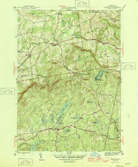
1946 Map of Grafton
USGS Topo · Published 1946About this map
Glacial ponds and small upland settlements define the landscape of eastern Rensselaer County in this mid-century survey. The area transitions from the lower farming grounds of Pittstown and Boyntonville in the north toward the high, lake-dotted plateau of Grafton. Water resources are a central theme, ranging from the southern Dunham Res and Quacken Kill to the cluster of ponds surrounding the village of Grafton, including Long Pond, Shaver Pond, and White Lily Pond. Local education and community life are marked by distributed landmarks such as the Groveside Sch and the Warren Cem. The prominent Dickerson Hill is capped by a Lookout Tower, overlooking a network of hollows like Ward Hollow and Couch Hollow that channeled early travel and commerce through this part of the Taconic foothills.
Find a feature on this map
41 named features on this map. Tap any name to fly to it.
Don’t see what you’re looking for? This feature index may not catch every label — zoom into the map to look around manually.
Map Details
Editions of this 1946 Grafton Map
2 editions found
Other maps of this area

1888 · Berlin
USGS Topo · 1:62,500

1890 · Berlin
USGS Topo · 1:62,500

1893 · Cohoes
USGS Topo · 1:62,500

1893 · Troy
USGS Topo · 1:62,500

1894 · Berlin
USGS Topo · 1:62,500

1895 · Troy
USGS Topo · 1:62,500

1895 · Cohoes
USGS Topo · 1:62,500

1897 · Hoosick
USGS Topo · 1:62,500

1898 · Berlin
USGS Topo · 1:62,500

1898 · Cohoes
USGS Topo · 1:62,500