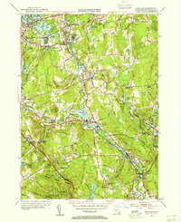
1953 Map of Grafton
USGS Topo · Published 1955About this map
The Blackstone River valley dominates this mid-century landscape, tracing a corridor of industrial villages and water-powered history. Settlements like Fisherville, Saundersville, and Farnumsville cluster along the riverbanks, where numerous impoundments such as Fisherville Pond and Rockdale Pond provided power for earlier mill operations. The transportation network is defined by the New Haven and Hartford and Providence and Worcester railroads, which parallel the river's path, connecting these manufacturing hubs to larger markets.
Find a feature on this map
94 named features on this map. Tap any name to fly to it.
Don’t see what you’re looking for? This feature index may not catch every label — zoom into the map to look around manually.
Map Details
Editions of this 1953 Grafton Map
4 editions found
Other maps of this area

1885 · Worcester
USGS Topo · 1:62,500

1886 · Worcester
USGS Topo · 1:62,500

1886 · Blackstone
USGS Topo · 1:62,500

1887 · Marlboro
USGS Topo · 1:62,500

1889 · Marlboro
USGS Topo · 1:62,500

1889 · Blackstone
USGS Topo · 1:62,500

1889 · Webster
USGS Topo · 1:62,500

1892 · Webster
USGS Topo · 1:62,500

1892 · Worcester
USGS Topo · 1:62,500

1893 · Blackstone
USGS Topo · 1:62,500