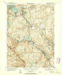
1953 Map of Grafton
USGS Topo · Published 1955About this map
The Blackstone River and Quinsigamond River valleys define this industrial and agricultural landscape in the mid-1950s. The region is marked by a string of mill settlements including Saundersville, Fisherville, and Farnumsville, which developed around the water power of the Blackstone. Further north, the Grafton State Hospital complex and the Grafton Airport represent the institutional and modern transport infrastructure of the era. The mapping details a transition from the dense residential pockets of North Grafton and Grafton to the more open, wooded terrain of the Sutton State Forest. Notable for local historians are the numerous burial grounds such as Riverside Cem and the Indian Cem, alongside landmarks like Purgatory Chasm State Park and several family-named hills like Brigham Hill and Keith Hill.
Find a feature on this map
86 named features on this map. Tap any name to fly to it.
Don’t see what you’re looking for? This feature index may not catch every label — zoom into the map to look around manually.
Map Details
Editions of this 1953 Grafton Map
4 editions found
Other maps of this area

1885 · Worcester
USGS Topo · 1:62,500

1886 · Worcester
USGS Topo · 1:62,500

1886 · Blackstone
USGS Topo · 1:62,500

1887 · Marlboro
USGS Topo · 1:62,500

1889 · Marlboro
USGS Topo · 1:62,500

1889 · Blackstone
USGS Topo · 1:62,500

1889 · Webster
USGS Topo · 1:62,500

1892 · Webster
USGS Topo · 1:62,500

1892 · Worcester
USGS Topo · 1:62,500

1893 · Blackstone
USGS Topo · 1:62,500