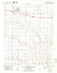
1979 Map of Grainfield
USGS Topo · Published 1979About this map
Grainfield sits along the Union Pacific line in Gove County, serving as a primary transportation and agricultural hub in the late 1970s. The town's layout is clearly defined, featuring the local Cem, Wheatland High Sch, and essential infrastructure like a Radio Tower and sewage disposal ponds. To the south, the settlement of Meyer marks a smaller node of activity in an otherwise expansive plains landscape divided into the townships of Grainfield, Payne, and Gove.
Find a feature on this map
23 named features on this map. Tap any name to fly to it.
Don’t see what you’re looking for? This feature index may not catch every label — zoom into the map to look around manually.
Map Details
Editions of this 1979 Grainfield Map
This is the sole edition of this map. No revisions or reprints were ever made.
Other maps of this area

1954 · Goodland
USGS Topo · 1:250,000

1955 · Scott City
USGS Topo · 1:250,000

1956 · Goodland
USGS Topo · 1:250,000

1957 · Goodland
USGS Topo · 1:250,000

1958 · Scott City
USGS Topo · 1:250,000

1972 · Gove NE
USGS Topo · 1:24,000

1972 · Orion NE
USGS Topo · 1:24,000

1972 · Gove
USGS Topo · 1:24,000

1979 · Park
USGS Topo · 1:24,000

1979 · Midway Draw West
USGS Topo · 1:24,000