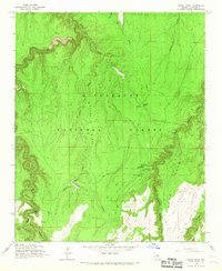
1965 Map of Grama Draw
USGS Topo · Published 1967About this map
Sitgreaves National Forest dominates this mid-1960s survey of the Arizona high country, where the landscape is defined by the deep incisions of West Chevelon Canyon and Alder Canyon. The map documents a rugged network of forest management and early ranching infrastructure, centered around the Chevelon Ranger Station and the Chevelon Butte Sch. Elevation changes are marked by dramatic features like Chevelon Butte and the long spine of Grama Ridge, while water management is evidenced by numerous livestock tanks such as Rock Trick Tank and Creswell Tank.
Find a feature on this map
26 named features on this map. Tap any name to fly to it.
Don’t see what you’re looking for? This feature index may not catch every label — zoom into the map to look around manually.
Map Details
Editions of this 1965 Grama Draw Map
3 editions found
Other maps of this area

1886 · Holbrook
USGS Topo · 1:250,000

1887 · Verde
USGS Topo · 1:250,000

1892 · Verde
USGS Topo · 1:250,000

1893 · Holbrook
USGS Topo · 1:250,000

1934 · Promontory Butte
USGS Topo · 1:62,500

1939 · Promontory Butte
USGS Topo · 1:62,500

1952 · Promontory Butte
USGS Topo · 1:62,500

1954 · Holbrook
USGS Topo · 1:250,000

1957 · Holbrook
USGS Topo · 1:250,000

1958 · Holbrook
USGS Topo · 1:250,000