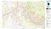
1984 Map of Grand Canyon
USGS Topo · Published 1984About this map
Colorado River carved the massive geology shown in this 1980s topographic study, which highlights the intersection of Indigenous lands and federal conservation. The Havasupai Indian Reservation and Hualapai Indian Reservation occupy significant portions of the canyon's western and southern reaches, with the isolated settlement of Supai located deep within the Cataract Creek drainage. Above the Granite Gorge, the landscape is defined by massive named landforms like Cheops Pyramid and Zoroaster Temple, reflecting the early 20th-century naming conventions used by surveyors.
Find a feature on this map
42 named features on this map. Tap any name to fly to it.
Don’t see what you’re looking for? This feature index may not catch every label — zoom into the map to look around manually.
Map Details
Editions of this 1984 Grand Canyon Map
2 editions found

Other maps of this area

1886 · Diamond Creek
USGS Topo · 1:250,000

1886 · San Francisco Mtns
USGS Topo · 1:250,000

1886 · Mt. Trumbull
USGS Topo · 1:250,000

1886 · Chino
USGS Topo · 1:250,000

1886 · Echo Cliffs
USGS Topo · 1:250,000

1886 · Kaibab
USGS Topo · 1:250,000

1891 · San Francisco Mtns
USGS Topo · 1:250,000

1891 · Chino
USGS Topo · 1:250,000

1891 · Echo Cliffs
USGS Topo · 1:250,000

1892 · Diamond Creek
USGS Topo · 1:250,000