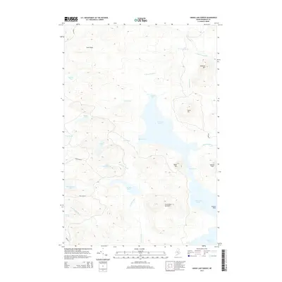
2014 Map of Grand Lake Seboeis
USGS Topo · Published 2014About this map
Grand Lake Seboeis dominates this landscape in Northern Maine, its waters punctuated by the Narrows and numerous inlets like Boody Cove and Coombs Cove. The surrounding terrain is defined by the Cunningham Mountains and individual peaks such as Wadleigh Mtn and Spoon Mtn, marking a heavily forested region managed through timber access. A network of logging roads, including Oxbow Rd and Soule Ridge Rd, provides the primary structure for movement through the timberlands, connecting isolated water bodies like Sawtelle Pond and Millimagassett Lake. This drainage system is part of a complex watershed where W Br Carry Brook and W Br Sawtelle Brook navigate the gaps between ridges like Swett Ridge and Jameson Ridge, illustrating the industrial and recreational geography of the Maine woods.
Find a feature on this map
34 named features on this map. Tap any name to fly to it.
Don’t see what you’re looking for? This feature index may not catch every label — zoom into the map to look around manually.
Map Details
Editions of this 2014 Grand Lake Seboeis Map
This is the sole edition of this map. No revisions or reprints were ever made.
Other maps of this area

1954 · Shin Pond
USGS Topo · 1:62,500

1954 · Millinocket Lake
USGS Topo · 1:62,500

1954 · Grand Lake Seboeis
USGS Topo · 1:62,500

1954 · Presque Isle
USGS Topo · 1:250,000

1955 · Traveler Mountain
USGS Topo · 1:62,500

1958 · Presque Isle
USGS Topo · 1:250,000

1960 · Presque Isle
USGS Topo · 1:250,000
1975 · Shin Pond NE
USGS Topo · 1:24,000
1975 · Shin Pond NW
USGS Topo · 1:24,000
1975 · Grand Lake Seboeis SE
USGS Topo · 1:24,000