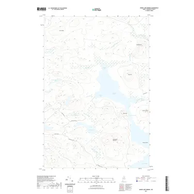
2021 Map of Grand Lake Seboeis
USGS Topo · Published 2021About this map
Grand Lake Seboeis and its complex network of inlets and coves dominate this landscape in Penobscot County, where the wilderness geography of Maine is defined by a dense system of glacial lakes and mountain ridges. The large lake body is segmented by features such as Coombs Cove and Boody Cove, while the restricted passage at The Narrows separates the main water from its southern reaches. To the east and south, the terrain rises into the Cunningham Mountains and Wadleigh Mtn, creating a high-relief boundary for the basin.
Find a feature on this map
33 named features on this map. Tap any name to fly to it.
Don’t see what you’re looking for? This feature index may not catch every label — zoom into the map to look around manually.
Map Details
Editions of this 2021 Grand Lake Seboeis Map
This is the sole edition of this map. No revisions or reprints were ever made.
Other maps of this area

1954 · Shin Pond
USGS Topo · 1:62,500

1954 · Millinocket Lake
USGS Topo · 1:62,500

1954 · Grand Lake Seboeis
USGS Topo · 1:62,500

1954 · Presque Isle
USGS Topo · 1:250,000

1955 · Traveler Mountain
USGS Topo · 1:62,500

1958 · Presque Isle
USGS Topo · 1:250,000

1960 · Presque Isle
USGS Topo · 1:250,000
1975 · Shin Pond NE
USGS Topo · 1:24,000
1975 · Shin Pond NW
USGS Topo · 1:24,000
1975 · Grand Lake Seboeis SE
USGS Topo · 1:24,000