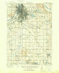
1943 Map of Grand Rapids
USGS Topo · Published 1943About this map
The Grand River carves through the heart of Kent County, defining the industrial and logistical footprint of Grand Rapids during the early 1940s. The city's growth is evident in the dense street grids and rail corridors of the Grand Trunk and Pere Marquette lines, which serve burgeoning suburbs like Burlingame and Beverly. Beyond the urban core, the landscape transitions into a network of rural school districts and small townships, where family-named landmarks like Whites Corner and institutional sites like the County Farm represent the era's civic life.
Find a feature on this map
88 named features on this map. Tap any name to fly to it.
Don’t see what you’re looking for? This feature index may not catch every label — zoom into the map to look around manually.
Map Details
Editions of this 1943 Grand Rapids Map
This is the sole edition of this map. No revisions or reprints were ever made.
Historical Maps of Grand Rapids Through Time
6 maps found