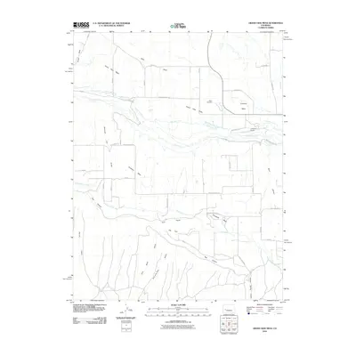
2010 Map of Grand View Mesa
USGS Topo · Published 2010About this map
Grand View Mesa and its neighboring plateaus, Fruitland Mesa and Crawford Mesa, define the geography of this Colorado landscape. The land is characterized by an extensive network of irrigation infrastructure necessary for high-desert agriculture, including the Grand View Ditch, the Gould Canal, and the Crawford Clipper Ditch. These man-made watercourses wind across the flat-topped mesas, diverting water from sources like the Smith Fork and Crystal Creek. Local history is anchored by landmarks such as the Olson Cemetery and the Crawford Airport, while the surrounding terrain is deeply incised by uniquely named drainages like Son-of-a-Gun Gulch, Diamond Joe Gulch, and the deep Red Canyon. This survey captures the complex intersection of natural geology and human-engineered water management in the early 21st century.
Find a feature on this map
56 named features on this map. Tap any name to fly to it.
Don’t see what you’re looking for? This feature index may not catch every label — zoom into the map to look around manually.
Map Details
Editions of this 2010 Grand View Mesa Map
This is the sole edition of this map. No revisions or reprints were ever made.
Other maps of this area

1955 · Black Ridge
USGS Topo · 1:24,000

1955 · Red Rock Canyon
USGS Topo · 1:24,000

1955 · Lazear
USGS Topo · 1:24,000

1956 · Montrose
USGS Topo · 1:250,000

1957 · Cathedral Peak
USGS Topo · 1:24,000

1957 · Grizzly Ridge
USGS Topo · 1:24,000

1959 · Montrose
USGS Topo · 1:250,000

1960 · Montrose
USGS Topo · 1:250,000
1965 · Paonia
USGS Topo · 1:24,000
1965 · Crawford
USGS Topo · 1:24,000