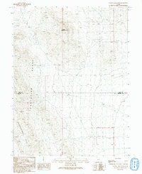
1991 Map of Granite Mountain
USGS Topo · Published 1991About this map
Granite Mountain dominates this portion of the West Desert, a remote landscape of the Great Basin where the Confusion Range meets the Disappointment Hills. Mapping of this high-altitude terrain reveals a complex network of 4wd tracks weaving through township and range lines, particularly along the border of Juab Co and Millard Co. The topographic detail shows the stark isolation of this region at the start of the 1990s, recording the precise contours of the basins and ridges that define this uninhabited corner of Utah. Surveyed as a provisional map, it captures the raw geography of the high desert before modern infrastructure reached these interior ranges, making it an essential reference for understanding the physical boundaries and early access routes of the Juab-Millard county line.
Find a feature on this map
7 named features on this map. Tap any name to fly to it.
Don’t see what you’re looking for? This feature index may not catch every label — zoom into the map to look around manually.
Map Details
Editions of this 1991 Granite Mountain Map
This is the sole edition of this map. No revisions or reprints were ever made.
Other maps of this area

1908 · Fish Springs
USGS Topo · 1:250,000

1910 · Fish Springs
USGS Topo · 1:250,000

1953 · Delta
USGS Topo · 1:250,000

1958 · Delta
USGS Topo · 1:250,000

1959 · Cowboy Pass
USGS Topo · 1:62,500

1960 · Granite Mountain
USGS Topo · 1:62,500

1960 · Gandy
USGS Topo · 1:62,500

1961 · Trout Creek
USGS Topo · 1:62,500

1962 · Delta
USGS Topo · 1:250,000
1979 · Fish Springs
USGS Topo · 1:100,000