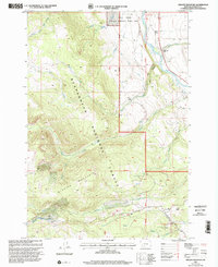
1997 Map of Granite Mountain
USGS Topo · Published 2002About this map
Granite Mountain dominates the southwestern portion of this Madison County landscape, marking a significant rise within the Beaverhead National Forest. This 1990s revision reveals a region defined by its conservation areas and water resources, including the Wall Creek State Wildlife Mgmt Area which covers the northeastern sector. The flow of the Madison River cuts through the northeast, bordered by the Wolf Creek Ranch and the Principal Meridian boundary.
Find a feature on this map
25 named features on this map. Tap any name to fly to it.
Don’t see what you’re looking for? This feature index may not catch every label — zoom into the map to look around manually.
Map Details
Editions of this 1997 Granite Mountain Map
This is the sole edition of this map. No revisions or reprints were ever made.
Other maps of this area

1888 · Three Forks
USGS Topo · 1:250,000

1894 · Three Forks
USGS Topo · 1:250,000

1895 · Three Forks
USGS Topo · 1:250,000

1947 · Bozeman
USGS Topo · 1:250,000

1948 · Bozeman
USGS Topo · 1:250,000

1949 · Varney
USGS Topo · 1:62,500

1950 · Cliff Lake
USGS Topo · 1:62,500

1950 · Cameron
USGS Topo · 1:62,500

1950 · Monument Ridge
USGS Topo · 1:62,500

1955 · Bozeman
USGS Topo · 1:250,000