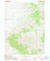
1990 Map of Granite Mountain
USGS Topo · Published 1990About this map
Granite Mountain and the East Range dominate this high-desert landscape in Pershing County, where complex geological formations drove a legacy of hard-rock exploration. The map reveals an intricate network of drainages including Mc Clure Canyon, Gold Note Canyon, and Lamberson Canyon, all converging in a region defined by its mineral potential. Prospectors and geologists can trace various extractive workings such as the Open Pit Mine and numerous Mine Tunnels Shaft Prospect sites located across the slopes. The topography is further punctuated by Cinnabar Ridge and Granite Peak, while scattered water sources like Root Spring Canyon provide vital landmarks in an otherwise arid environment. This provisional survey captures the intersection of industrial pursuit and natural relief, documenting the specific locations of mine shafts and tunnels that shaped local history.
Find a feature on this map
32 named features on this map. Tap any name to fly to it.
Don’t see what you’re looking for? This feature index may not catch every label — zoom into the map to look around manually.
Map Details
Editions of this 1990 Granite Mountain Map
This is the sole edition of this map. No revisions or reprints were ever made.
Other maps of this area

1932 · Sonoma Range
USGS Topo · 1:250,000

1939 · Sonoma Range
USGS Topo · 1:250,000

1955 · Winnemucca
USGS Topo · 1:250,000

1958 · Winnemucca
USGS Topo · 1:250,000
1961 · Kyle Hot Springs
USGS Topo · 1:62,500

1961 · Mt. Tobin
USGS Topo · 1:62,500

1961 · Cain Mountain
USGS Topo · 1:62,500

1961 · Fencemaker
USGS Topo · 1:62,500

1962 · Winnemucca
USGS Topo · 1:250,000

1982 · Fish Creek Mts
USGS Topo · 1:100,000