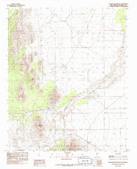
1985 Map of Granite Mountain
USGS Topo · Published 1985About this map
Magdalena sits at the southern edge of this mid-1980s survey, marking a point of transition between the high desert floor and the rising peaks of the Cibola National Forest. The landscape is dominated by the prominent mass of Granite Mountain, a landmark that anchors the western portion of the quadrangle. North of the mountain, the terrain is cut by drainage systems including Bear Springs Canyon and Goat Spring, while La Jencia Creek winds through the eastern flats.
Find a feature on this map
11 named features on this map. Tap any name to fly to it.
Don’t see what you’re looking for? This feature index may not catch every label — zoom into the map to look around manually.
Map Details
Editions of this 1985 Granite Mountain Map
This is the sole edition of this map. No revisions or reprints were ever made.
Other maps of this area

1954 · Socorro
USGS Topo · 1:250,000

1958 · Socorro
USGS Topo · 1:250,000

1959 · Magdalena
USGS Topo · 1:62,500

1959 · Riley
USGS Topo · 1:62,500

1962 · Socorro
USGS Topo · 1:250,000

1963 · Arroyo Landavaso
USGS Topo · 1:24,000

1964 · Silver Hill
USGS Topo · 1:24,000
1964 · Mesa Cencerro
USGS Topo · 1:24,000
1979 · Magdalena
USGS Topo · 1:100,000
1985 · San Lorenzo Spring
USGS Topo · 1:24,000