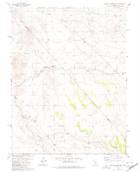
1980 Map of Granny Goose Well
USGS Topo · Published 1980About this map
Stewart Valley defines the arid landscape of this 1980 survey, where the border of Nye and Mineral counties cuts diagonally across high desert terrain. The area is characterized by a network of drainage systems including Antone Wash and Finger Rock Wash, which channel water toward the valley floor during infrequent rains. Human activity in this remote region is marked by isolated landmarks like Granny Goose Well and Indian Well, alongside signs of early habitation at the Antone Station (Site). Mineral exploration is evident throughout the hills, with several prospects, a mine, and multiple borrow pits scattered near the jeep trails that provide the only access to the interior. The presence of Rawhide Ranch indicates the persistent, though sparse, agricultural and residential footprint in this section of the Great Basin.
Find a feature on this map
17 named features on this map. Tap any name to fly to it.
Don’t see what you’re looking for? This feature index may not catch every label — zoom into the map to look around manually.
Map Details
Editions of this 1980 Granny Goose Well Map
This is the sole edition of this map. No revisions or reprints were ever made.
Other maps of this area

1907 · Tonopah
USGS Topo · 1:250,000

1908 · Tonopah
USGS Topo · 1:250,000

1909 · Hawthorne
USGS Topo · 1:250,000

1911 · Hawthorne
USGS Topo · 1:250,000

1915 · Hawthorne
USGS Topo · 1:250,000

1948 · Paradise Peak
USGS Topo · 1:62,500

1948 · Walker Lake
USGS Topo · 1:250,000

1950 · Paradise Peak
USGS Topo · 1:62,500

1956 · Tonopah
USGS Topo · 1:250,000

1957 · Walker Lake
USGS Topo · 1:250,000