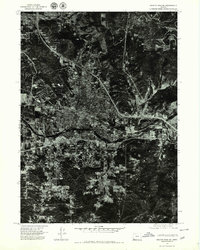
1974 Map of Grants Pass NE
USGS Topo · Published 1979About this map
Grants Pass sits at the heart of this 1974 orthophotoquad, which uses aerial photography to show the precise physical footprint of the city during a period of significant growth. Unlike standard topographic maps, this aerial perspective reveals the exact density of residential blocks and the expanding commercial corridors during the mid-1970s. The Rogue River carves through the southern portion of the city, serving as the primary geographical anchor for the local landscape. To the north, the winding course of Louse Creek and the drainage of Gilbert Creek define the edges of the developed town. This map provides an unfiltered look at the intersection of early Interstate construction and the existing local street grid, offering a clear record of the area's development before further modern expansion altered the city's outskirts.
Find a feature on this map
4 named features on this map. Tap any name to fly to it.
Don’t see what you’re looking for? This feature index may not catch every label — zoom into the map to look around manually.
Map Details
Editions of this 1974 Grants Pass NE Map
2 editions found
Other maps of this area

1904 · Riddle
USGS Topo · 1:125,000

1908 · Grants Pass
USGS Topo · 1:125,000

1954 · Glendale
USGS Topo · 1:62,500

1954 · Gold Hill
USGS Topo · 1:62,500

1954 · Wimer
USGS Topo · 1:62,500

1954 · Grants Pass
USGS Topo · 1:62,500

1955 · Medford
USGS Topo · 1:250,000

1957 · Medford
USGS Topo · 1:250,000

1958 · Medford
USGS Topo · 1:250,000

1974 · Grants Pass NW
USGS Topo · 1:24,000