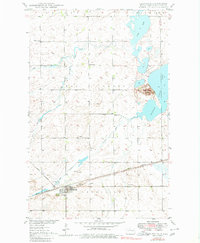
1949 Map of Granville
USGS Topo · Published 1980About this map
The town of Granville sits as a central hub in McHenry County, anchored by the Great Northern railroad tracks that cut across the southern prairie. This late-1940s landscape is defined by its complex drainage systems, including Egg Creek, South Egg Creek, and the winding Hay Coulee. To the east, the waters of Buffalo Lake and North Lake dominate the terrain, separated by the prominent Buffalo Lodge Butte.
Find a feature on this map
18 named features on this map. Tap any name to fly to it.
Don’t see what you’re looking for? This feature index may not catch every label — zoom into the map to look around manually.
Map Details
Editions of this 1949 Granville Map
2 editions found
Other maps of this area

1948 · Velva
USGS Topo · 1:62,500

1949 · Norwich
USGS Topo · 1:24,000

1949 · Granville NE
USGS Topo · 1:24,000

1949 · Simcoe
USGS Topo · 1:24,000

1949 · Granville NW
USGS Topo · 1:24,000

1949 · Riga
USGS Topo · 1:24,000

1949 · Granville SW
USGS Topo · 1:24,000

1949 · Karlsruhe NW
USGS Topo · 1:24,000

1949 · Granville
USGS Topo · 1:24,000

1950 · Bantry NW
USGS Topo · 1:24,000