
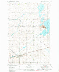
1949 Map of Granville
USGS Topo · Published 1949About this map
The town of Granville serves as the focal point of this McHenry County landscape, situated along the southern edge of the sheet where the Great Northern railroad provides a critical transportation link. The topography is defined by the winding paths of Egg Creek and its tributary South Egg Creek, which drain toward the prominent Buffalo Lodge Lake in the east. North of the lake, Buffalo Lodge Butte rises as a distinct landmark in an otherwise prairie environment. The presence of numbered rural schoolhouses, including School No 1, School No 2, and School No 4, highlights a decentralized educational system typical of North Dakota's mid-century farming communities. Beyond the town limits, the land is marked by several Gravel Pits and numerous Windmills, indicating an economy tied to both local infrastructure development and livestock water management during the early post-war years.
Find a feature on this map
17 named features on this map. Tap any name to fly to it.
Don’t see what you’re looking for? This feature index may not catch every label — zoom into the map to look around manually.
Map Details
Editions of this 1949 Granville Map
2 editions found
Other maps of this area

1948 · Velva
USGS Topo · 1:62,500

1949 · Norwich
USGS Topo · 1:24,000

1949 · Granville NE
USGS Topo · 1:24,000

1949 · Simcoe
USGS Topo · 1:24,000

1949 · Granville NW
USGS Topo · 1:24,000

1949 · Riga
USGS Topo · 1:24,000

1949 · Granville SW
USGS Topo · 1:24,000

1949 · Karlsruhe NW
USGS Topo · 1:24,000

1950 · Bantry NW
USGS Topo · 1:24,000

1951 · Velva
USGS Topo · 1:62,500