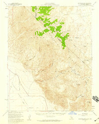
1957 Map of Grapevine Peak
USGS Topo · Published 1959About this map
Grapevine Mountains dominate this high-desert terrain, straddling the border between California and Nevada during the mid-1950s. The landscape is defined by dramatic elevation changes, dropping from the summit of Grapevine Peak down into the northern reaches of the Death Valley basin at Mesquite Flat. This era captures the remote infrastructure of the region, featuring a network of primitive routes like the Leadfield Road and various unnamed jeep trails that provided access to isolated resource sites.
Find a feature on this map
30 named features on this map. Tap any name to fly to it.
Don’t see what you’re looking for? This feature index may not catch every label — zoom into the map to look around manually.
Map Details
Editions of this 1957 Grapevine Peak Map
4 editions found
Other maps of this area

1908 · Kawich
USGS Topo · 1:250,000

1908 · Lida
USGS Topo · 1:250,000

1908 · Furnace Creek
USGS Topo · 1:250,000

1908 · Ballarat
USGS Topo · 1:250,000

1910 · Furnace Creek
USGS Topo · 1:250,000

1913 · Lida
USGS Topo · 1:250,000

1913 · Ballarat
USGS Topo · 1:250,000

1942 · Tolicha Peak
USGS Topo · 1:125,000

1942 · Bullfrog
USGS Topo · 1:125,000

1948 · Death Valley
USGS Topo · 1:250,000