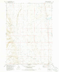
1979 Map of Grasmere
USGS Topo · Published 1986About this map
Wickahoney and Grasmere anchor this high-desert Owyhee County landscape during the late 1970s, a region defined by its reliance on seasonal water sources and expansive grazing lands. The map highlights the sparse infrastructure of the era, marked by a network of Jeep Trails connecting remote locations like the Sego Place (Site). Water is the primary driver of movement and habitation here, with multiple unnamed Springs feeding into drainage systems like Wickahoney Creek, China Creek, and Nanny Creek. Prominent geological landmarks such as Poison Butte and Gedney Butte rise above the terrain, providing essential orientation points in the open country. Local history is etched into the land through features like a lone Grave and a functional Corral, suggesting the quiet presence of ranching life and early homesteading efforts in this corner of Idaho.
Find a feature on this map
16 named features on this map. Tap any name to fly to it.
Don’t see what you’re looking for? This feature index may not catch every label — zoom into the map to look around manually.
Map Details
Editions of this 1979 Grasmere Map
This is the sole edition of this map. No revisions or reprints were ever made.
Other maps of this area

1955 · Jordan Valley
USGS Topo · 1:250,000

1955 · Twin Falls
USGS Topo · 1:250,000

1956 · Big Hill
USGS Topo · 1:62,500

1957 · Jordan Valley
USGS Topo · 1:250,000

1958 · Twin Falls
USGS Topo · 1:250,000

1958 · Jordan Valley
USGS Topo · 1:250,000
1972 · Hill Pasture
USGS Topo · 1:24,000

1972 · Wickahoney Point
USGS Topo · 1:24,000

1972 · Little Blue Table
USGS Topo · 1:24,000

1979 · Blackstone Reservoir
USGS Topo · 1:24,000