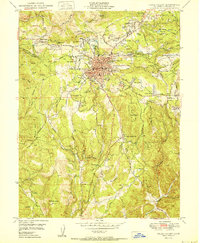
1950 Map of Grass Valley
USGS Topo · Published 1950About this map
Gold mining operations dominate the landscape around Grass Valley at the mid-century, reflecting decades of hard-rock extraction in the northern Mother Lode. Massive workings such as the Empire Mine, the North Star Mine, and the Idaho-Maryland Mine flank the town center, while features like the Tailings Ponds and the North Star Central Shaft indicate the industrial scale of these operations. The settlement pattern follows the gold, with small communities like Boston Ravine, Hills Flat, and Glenbrook clustered near the claims.
Find a feature on this map
77 named features on this map. Tap any name to fly to it.
Don’t see what you’re looking for? This feature index may not catch every label — zoom into the map to look around manually.
Map Details
Editions of this 1950 Grass Valley Map
This is the sole edition of this map. No revisions or reprints were ever made.
Other maps of this area

1888 · Smartsville
USGS Topo · 1:125,000

1891 · Colfax
USGS Topo · 1:125,000

1891 · Smartsville
USGS Topo · 1:125,000

1892 · Smartsville
USGS Topo · 1:125,000

1892 · Colfax
USGS Topo · 1:125,000

1894 · Colfax
USGS Topo · 1:125,000

1894 · Smartsville
USGS Topo · 1:125,000

1895 · Smartsville
USGS Topo · 1:125,000

1898 · Colfax
USGS Topo · 1:125,000

1900 · Colfax
USGS Topo · 1:125,000