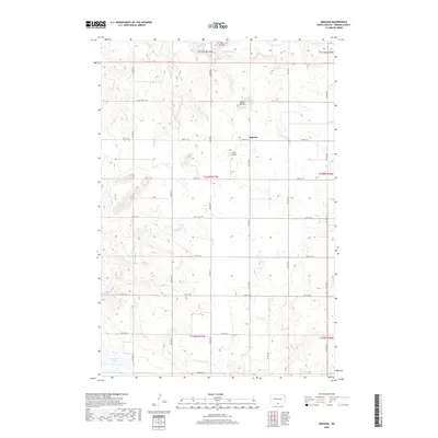
2018 Map of Grassna
USGS Topo · Published 2018About this map
The settlement of Grassna sits amidst the characteristic rolling prairie of southern North Dakota, where the high plains are punctuated by prominent landforms like Volk Butte, Braun Butte, and Lone Butte. This landscape is defined by the section-line road grid, including 91st St SE and 92nd St SE, which dictates the layout of agricultural tracts and local travel. Hydrological patterns in the area are shaped by several seasonal and permanent watercourses, most notably Little Beaver Cr and Cattail Cr, which carve shallow paths through the terrain. In the southwestern corner, the presence of Becker Lake provides a localized basin for drainage. The map reveals a spatial arrangement typical of Emmons County, where isolated buttes served as essential navigational landmarks for early inhabitants across the expansive grasslands.
Find a feature on this map
22 named features on this map. Tap any name to fly to it.
Don’t see what you’re looking for? This feature index may not catch every label — zoom into the map to look around manually.
Map Details
Editions of this 2018 Grassna Map
This is the sole edition of this map. No revisions or reprints were ever made.
Other maps of this area

1953 · McIntosh
USGS Topo · 1:250,000

1954 · Bismarck
USGS Topo · 1:250,000

1958 · Bismarck
USGS Topo · 1:250,000

1958 · McIntosh
USGS Topo · 1:250,000

1965 · Herreid NW
USGS Topo · 1:24,000

1965 · Pollock
USGS Topo · 1:24,000

1966 · Pollock NW
USGS Topo · 1:24,000

1971 · Grassna NW
USGS Topo · 1:24,000
1971 · Kiefer Buttes
USGS Topo · 1:24,000
1971 · Grassna
USGS Topo · 1:24,000