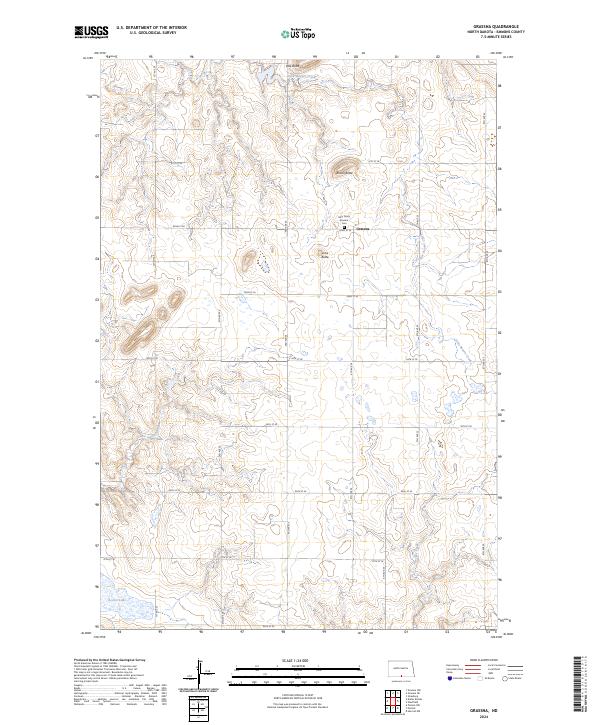
2024 Map of Grassna
USGS Topo · Published 2024About this map
Grassna serves as the focal point of this high-plains landscape in North Dakota, where the cultural heart of the community is anchored by the Holy Trinity Krassna Cem. The surrounding terrain is defined by a series of prominent rises, including Volk Butte, Braun Butte, and Lone Butte, which stand as landmarks across the prairie. This 2024 survey depicts a rural environment where land management is organized by a grid of numbered roads, such as 91st St SE and 98th St SE, intersecting the various sections and ranges. Water is scarce but vital, with the drainages of Little Beaver Creek, Cattail Creek, and Becker Creek cutting through the fields, while Becker Lake provides a rare localized water body in the southwestern corner. The map reflects a modern rural economy still heavily reliant on the section-line road system and the legacy of early settlements.
Find a feature on this map
24 named features on this map. Tap any name to fly to it.
Don’t see what you’re looking for? This feature index may not catch every label — zoom into the map to look around manually.
Map Details
Editions of this 2024 Grassna Map
This is the sole edition of this map. No revisions or reprints were ever made.
Other maps of this area

1953 · McIntosh
USGS Topo · 1:250,000

1954 · Bismarck
USGS Topo · 1:250,000

1958 · Bismarck
USGS Topo · 1:250,000

1958 · McIntosh
USGS Topo · 1:250,000

1965 · Herreid NW
USGS Topo · 1:24,000

1965 · Pollock
USGS Topo · 1:24,000

1966 · Pollock NW
USGS Topo · 1:24,000

1971 · Grassna NW
USGS Topo · 1:24,000
1971 · Kiefer Buttes
USGS Topo · 1:24,000
1971 · Grassna
USGS Topo · 1:24,000