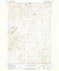
1971 Map of Grassna
USGS Topo · Published 1973About this map
Grassna serves as the small hub for this agricultural portion of Emmons County during the early 1970s. The landscape is defined by the high points of Volk Butte, Braun Butte, and Lone Butte, which rise above the drainage networks of Little Beaver Creek and Cattail Creek. The social and communal center is clearly identified at Holy Trinity Ch, located just north of the town center near a prominent Radio Tower. The geography reflects a sparsely populated farming region where water features like Becker Lake and small industrial sites such as a Gravel Pit are the primary landmarks. This survey, based on 1969 photography and 1971 field checks, provides a precise look at the rural section lines and homestead placements that defined this North Dakota community before modern consolidation changed the local settlement pattern.
Find a feature on this map
10 named features on this map. Tap any name to fly to it.
Don’t see what you’re looking for? This feature index may not catch every label — zoom into the map to look around manually.
Map Details
Editions of this 1971 Grassna Map
This is the sole edition of this map. No revisions or reprints were ever made.
Other maps of this area

1953 · McIntosh
USGS Topo · 1:250,000

1954 · Bismarck
USGS Topo · 1:250,000

1958 · Bismarck
USGS Topo · 1:250,000

1958 · McIntosh
USGS Topo · 1:250,000

1965 · Herreid NW
USGS Topo · 1:24,000

1965 · Pollock
USGS Topo · 1:24,000

1966 · Pollock NW
USGS Topo · 1:24,000

1971 · Grassna NW
USGS Topo · 1:24,000
1971 · Kiefer Buttes
USGS Topo · 1:24,000

1971 · Grassna NE
USGS Topo · 1:24,000