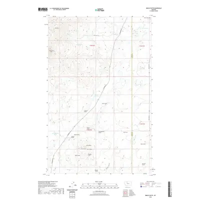
2020 Map of Grassy Butte
USGS Topo · Published 2020About this map
The Sweet Grass Hills dominate the northwestern corner of this landscape, where the terrain breaks into a series of deeply etched drainages. The map reveals a ranching country defined by its water sources, from the Morris Reservoir and Chicago Lake to the scattered springs like Alkali Spring and 35N03E20AACC01 Spring. This high plains environment is dissected by numerous named coulees, including La Planté Coulee and Grandma Coulee, suggesting a long history of local naming conventions for the many folds in the land.
Find a feature on this map
35 named features on this map. Tap any name to fly to it.
Don’t see what you’re looking for? This feature index may not catch every label — zoom into the map to look around manually.
Map Details
Editions of this 2020 Grassy Butte Map
This is the sole edition of this map. No revisions or reprints were ever made.
Other maps of this area

1954 · Shelby
USGS Topo · 1:250,000

1958 · Shelby
USGS Topo · 1:250,000

1962 · Whitlash
USGS Topo · 1:24,000

1962 · Cameron Lake
USGS Topo · 1:24,000

1962 · Hawthorne School
USGS Topo · 1:24,000

1962 · Berkholder Reservoir
USGS Topo · 1:24,000

1962 · Blair Ranch
USGS Topo · 1:24,000

1962 · Fey Lakes
USGS Topo · 1:24,000
1962 · Hawley Hill
USGS Topo · 1:24,000

1962 · Haystack Butte
USGS Topo · 1:24,000