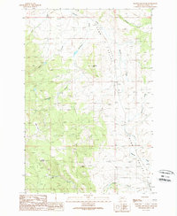
1989 Map of Gravely Mountain
USGS Topo · Published 1989About this map
Gravely Mountain anchors the southern portion of this landscape, where mining operations were once active during the late twentieth century. Economic activity in this corner of the state is evidenced by the Gravely Mine and Gimlet Mine, located along the slopes above Gimlet Creek. The terrain is defined by the broad Avon Valley to the east and a series of drainage systems, including Strickland Creek and Finn Creek, which carve through the high country. Small-scale ranching or livestock infrastructure is noted by a Corral near Halfway Creek, illustrating the land's utility for both mineral extraction and grazing. The presence of several 4wd tracks suggests a period of transition where traditional resource extraction routes remained the primary means of navigating this part of Powell County.
Find a feature on this map
17 named features on this map. Tap any name to fly to it.
Don’t see what you’re looking for? This feature index may not catch every label — zoom into the map to look around manually.
Map Details
Editions of this 1989 Gravely Mountain Map
This is the sole edition of this map. No revisions or reprints were ever made.
Other maps of this area

1889 · Helena
USGS Topo · 1:250,000

1893 · Helena
USGS Topo · 1:250,000

1899 · Helena
USGS Topo · 1:250,000

1903 · Helena
USGS Topo · 1:250,000

1947 · Butte
USGS Topo · 1:250,000

1958 · Butte
USGS Topo · 1:250,000

1958 · Avon
USGS Topo · 1:62,500

1958 · Garrison
USGS Topo · 1:62,500

1960 · Butte
USGS Topo · 1:250,000

1962 · Butte
USGS Topo · 1:250,000