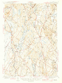
1944 Map of Gray
USGS Topo · Published 1944About this map
Gray serves as a central hub in this Cumberland County landscape, where the Maine Central railroad and a network of early roads connect inland settlements during the early 1940s. The map reveals a dense arrangement of village centers and rural stations, including New Gloucester Sta and Cumberland Center Sta, which anchored the local economy alongside water-powered sites like Dry Mills. The terrain is defined by a series of prominent elevations such as Pismire Mtn and Mt Independence, interspersed with numerous bodies of water including Highland Lake and the religious community at Sabbathday Lake.
Find a feature on this map
139 named features on this map. Tap any name to fly to it.
Don’t see what you’re looking for? This feature index may not catch every label — zoom into the map to look around manually.
Map Details
Editions of this 1944 Gray Map
3 editions found
Other maps of this area

1891 · Portland
USGS Topo · 1:62,500

1891 · Buxton
USGS Topo · 1:62,500

1892 · Freeport
USGS Topo · 1:62,500

1892 · Buxton
USGS Topo · 1:62,500

1893 · Portland
USGS Topo · 1:62,500

1893 · Casco Bay
USGS Topo · 1:62,500

1893 · Buxton
USGS Topo · 1:62,500

1894 · Gray
USGS Topo · 1:62,500

1896 · Norway
USGS Topo · 1:62,500

1896 · Sebago
USGS Topo · 1:62,500