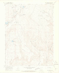
1965 Map of Gray Reservoir
USGS Topo · Published 1968About this map
Grand Mesa and Oak Mesa dominate this mid-century landscape in Delta County, where high-altitude water management and mineral extraction shaped the local economy. The terrain is defined by an extensive network of irrigation infrastructure, including the Schoneman-Ditch Camp, numerous ditches, and an aqueduct serving the lower elevations. Numerous small bodies of water, such as Gray Reservoir, Patterson Reservoirs, and Lost Hunter Reservoir, are scattered across the plateau, highlighting the critical role of water storage in this part of the Gunnison National Forest. Evidence of the region's mining history is preserved through the Fitzsimons Mines and Burdick Mine. Movement across this complex topography of West Long Draw and High Park is facilitated by a network of jeep trails, including the Overland Jeep Trail, which follow the natural contours and ridges of the mesas.
Find a feature on this map
39 named features on this map. Tap any name to fly to it.
Don’t see what you’re looking for? This feature index may not catch every label — zoom into the map to look around manually.
Map Details
Editions of this 1965 Gray Reservoir Map
4 editions found
Other maps of this area

1955 · Lazear
USGS Topo · 1:24,000

1956 · Montrose
USGS Topo · 1:250,000

1957 · Leadville
USGS Topo · 1:250,000

1959 · Leadville
USGS Topo · 1:250,000

1959 · Montrose
USGS Topo · 1:250,000

1960 · Leadville
USGS Topo · 1:250,000

1960 · Montrose
USGS Topo · 1:250,000

1960 · Leon Peak
USGS Topo · 1:24,000

1961 · Electric Mountain
USGS Topo · 1:24,000

1961 · Chalk Mountain
USGS Topo · 1:24,000