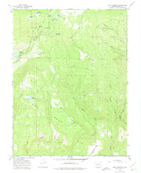
1965 Map of Gray Reservoir
USGS Topo · Published 1975About this map
Grand Mesa dominates this high-altitude landscape of western Colorado, where a complex network of man-made irrigation features and high-country reservoirs supported the surrounding valley's ranching and agriculture. In this mid-1960s survey, the terrain is defined by the transition from the timbered heights of the Grand Mesa National Forest and Gunnison National Forest down across expansive tables like Oak Mesa and Wakefield Mesa. Water management is the primary human imprint, evidenced by the Overland Ditch, Roatcap Ditch, and Schoneman Ditch Camp, which funneled snowmelt into basins such as Patterson Reservoirs and West Reservoir No 1. Mining activity is also recorded in the southern reaches of the quadrangle, including the Burdick Mine and the Fitzsimons Mines near The Basin, reflecting the diverse industrial utility of these mesas.
Find a feature on this map
43 named features on this map. Tap any name to fly to it.
Don’t see what you’re looking for? This feature index may not catch every label — zoom into the map to look around manually.
Map Details
Editions of this 1965 Gray Reservoir Map
4 editions found
Other maps of this area

1955 · Lazear
USGS Topo · 1:24,000

1956 · Montrose
USGS Topo · 1:250,000

1957 · Leadville
USGS Topo · 1:250,000

1959 · Leadville
USGS Topo · 1:250,000

1959 · Montrose
USGS Topo · 1:250,000

1960 · Leadville
USGS Topo · 1:250,000

1960 · Montrose
USGS Topo · 1:250,000

1960 · Leon Peak
USGS Topo · 1:24,000

1961 · Electric Mountain
USGS Topo · 1:24,000

1961 · Chalk Mountain
USGS Topo · 1:24,000