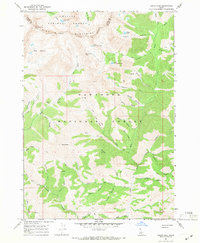
1967 Map of Grays Peak
USGS Topo · Published 1971About this map
Pioneer Mountains peaks dominate this high-altitude landscape along the border of Custer and Blaine counties. This mid-century survey captures a wilderness interface where the Challis National Forest and Sawtooth National Forest meet. Prospecting history is etched into the terrain at the Sunshine Mine, Mascot Mine, and Iron Mine, while numerous pack trails provide the only access through steep features like Paymaster Gulch and Snowslide Gulch. The hydrology of the region is defined by glacial remnants such as Arrowhead Lake, Windy Lake, and the tiered Upper Box Canyon Lake and Lower Box Canyon Lake. These waters feed the Wood River and Little Wood River systems, which flow south through narrow corridors like Box Canyon and Schuss Canyon. The map records a moment of isolated mountain activity, including a Jeep Trail and remote markers like Brocky and Pasture.
Find a feature on this map
47 named features on this map. Tap any name to fly to it.
Don’t see what you’re looking for? This feature index may not catch every label — zoom into the map to look around manually.
Map Details
Editions of this 1967 Grays Peak Map
3 editions found
Other maps of this area

1895 · Hailey
USGS Topo · 1:125,000

1897 · Hailey
USGS Topo · 1:125,000

1935 · MacKay
USGS Topo · 1:96,000

1955 · Idaho Falls
USGS Topo · 1:250,000

1955 · Hailey
USGS Topo · 1:250,000

1958 · Idaho Falls
USGS Topo · 1:250,000

1959 · Hailey
USGS Topo · 1:250,000

1960 · Muldoon Canyon
USGS Topo · 1:62,500

1960 · Copper Basin
USGS Topo · 1:62,500

1962 · Hailey
USGS Topo · 1:250,000