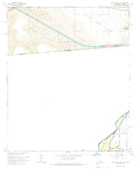
1964 Map of Grays Well NE
USGS Topo · Published 1966About this map
The Colorado River and the international border between the United States and Mexico anchor this arid landscape in the mid-1960s. The region is defined by the massive engineering of the All American Canal, which cuts through the Sand Hills to bring water to the desert. To the east, the Pilot Knob Mesa rises toward the landmark peak of Pilot Knob, while the southern portion of the sheet reveals the agricultural transition of the Yuma Valley. This area includes the northern extent of the Cocopah Indian Reservation, showing the interaction between tribal lands and the developing infrastructure of the Southern Pacific railroad and smaller irrigation works like the Pesch Canal.
Find a feature on this map
17 named features on this map. Tap any name to fly to it.
Don’t see what you’re looking for? This feature index may not catch every label — zoom into the map to look around manually.
Map Details
Editions of this 1964 Grays Well NE Map
4 editions found
Other maps of this area

1903 · Yuma
USGS Topo · 1:125,000

1905 · Yuma
USGS Topo · 1:125,000

1940 · Yuma
USGS Topo · 1:62,500

1942 · Yuma
USGS Topo · 1:250,000

1945 · Picacho Peak
USGS Topo · 1:62,500

1945 · Yuma
USGS Topo · 1:62,500

1951 · Picacho Peak
USGS Topo · 1:62,500

1952 · Araz
USGS Topo · 1:24,000

1952 · Yuma West
USGS Topo · 1:24,000

1953 · Grays Well
USGS Topo · 1:24,000