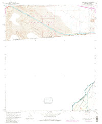
1964 Map of Grays Well NE
USGS Topo · Published 1979About this map
The United States Mexico international boundary defines this arid borderland where the shifting Sand Hills meet the engineered waterways of the Colorado River valley. The massive All American Canal cuts a straight path across the Imperial Sand Dunes Recreation Lands, highlighting the mid-century effort to move water through the desert. To the southeast, the Colorado River serves as the boundary between Baja California Norte and Arizona, weaving past the Cocopah Indian Reservation.
Find a feature on this map
23 named features on this map. Tap any name to fly to it.
Don’t see what you’re looking for? This feature index may not catch every label — zoom into the map to look around manually.
Map Details
Editions of this 1964 Grays Well NE Map
4 editions found
Other maps of this area

1903 · Yuma
USGS Topo · 1:125,000

1905 · Yuma
USGS Topo · 1:125,000

1940 · Yuma
USGS Topo · 1:62,500

1942 · Yuma
USGS Topo · 1:250,000

1945 · Picacho Peak
USGS Topo · 1:62,500

1945 · Yuma
USGS Topo · 1:62,500

1951 · Picacho Peak
USGS Topo · 1:62,500

1952 · Araz
USGS Topo · 1:24,000

1952 · Yuma West
USGS Topo · 1:24,000

1953 · Grays Well
USGS Topo · 1:24,000