
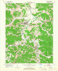
1953 Map of Grayson
USGS Topo · Published 1954About this map
The Little Sandy River meanders through this portion of Carter County, anchoring a landscape defined by sharp ridges and deep hollows like Bourbon Hollow and Schoolhouse Hollow. The seat at Grayson serves as the central hub, home to Kentucky Christian College and situated along the historic Midland Trail. The transport geography of the early 1950s is clearly visible, with the Chesapeake and Ohio railroad following the river valley through industrial and residential points such as Hitehins and Leon.
Find a feature on this map
71 named features on this map. Tap any name to fly to it.
Don’t see what you’re looking for? This feature index may not catch every label — zoom into the map to look around manually.
Map Details
Editions of this 1953 Grayson Map
2 editions found
Other maps of this area

1903 · Kenova
USGS Topo · 1:125,000

1904 · Kenova
USGS Topo · 1:125,000

1950 · Bruin
USGS Topo · 1:24,000

1950 · Grahn
USGS Topo · 1:24,000

1950 · Tygarts Valley
USGS Topo · 1:24,000

1953 · Oldtown
USGS Topo · 1:24,000

1953 · Rush
USGS Topo · 1:24,000
1953 · Argillite
USGS Topo · 1:24,000
1953 · Webbville
USGS Topo · 1:24,000
1953 · Willard
USGS Topo · 1:24,000