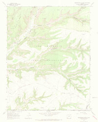
1966 Map of Greasewood Canyon
USGS Topo · Published 1969About this map
The Mancos River carves through the landscape of the Ute Mountain Indian Reservation in this 1966 field survey, revealing a dense concentration of archaeological sites. Steep canyon walls and high mesas, including Chapin Mesa, are punctuated by ancient masonry structures such as Sixteen Window House, Double Walled Tower, and Eagle Nest House. Numerous other Cliff Dwellings and Indian Ruins are documented throughout Johnson Canyon and Greasewood Canyon.
Find a feature on this map
28 named features on this map. Tap any name to fly to it.
Don’t see what you’re looking for? This feature index may not catch every label — zoom into the map to look around manually.
Map Details
Editions of this 1966 Greasewood Canyon Map
3 editions found
Other maps of this area

1889 · Chaco
USGS Topo · 1:250,000

1892 · Chaco
USGS Topo · 1:250,000

1912 · Soda Canyon
USGS Topo · 1:62,500

1915 · Soda Canyon
USGS Topo · 1:62,500

1934 · Chimney Rock
USGS Topo · 1:62,500

1936 · Chimney Rock
USGS Topo · 1:62,500

1954 · Shiprock
USGS Topo · 1:250,000

1956 · Cortez
USGS Topo · 1:250,000

1958 · Cortez
USGS Topo · 1:250,000

1958 · Shiprock
USGS Topo · 1:250,000