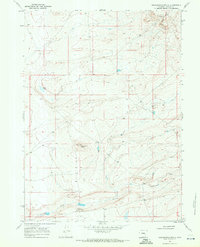
1968 Map of Greasewood Knoll
USGS Topo · Published 1972About this map
The livestock ranching landscape of Albany County is clearly defined on this 1968 study, dominated by the Greasewood Knoll landform and the intricate drainage of Greasewood Creek. A rare glimpse into the practical infrastructure of the high plains, the map documents the Laycock Shearing Pens and a large Corral near the center of the sheet, illustrating the region's agricultural focus. Local movement was facilitated by the Marshall Road and the Fort Fetterman Road, which connect this high-plateau terrain to larger regional hubs. Water sources, vital for sheep and cattle, are sparse but identified at Budge Lake, Soda Spring, and along the winding Bone Creek. From Prairie Point in the north to the shearing facilities in the south, the map preserves the functional layout of a mid-century Wyoming ranching district.
Find a feature on this map
10 named features on this map. Tap any name to fly to it.
Don’t see what you’re looking for? This feature index may not catch every label — zoom into the map to look around manually.
Map Details
Editions of this 1968 Greasewood Knoll Map
This is the sole edition of this map. No revisions or reprints were ever made.
Other maps of this area

1915 · Como Ridge
USGS Topo · 1:48,000

1918 · Como Ridge
USGS Topo · 1:62,500

1954 · Torrington
USGS Topo · 1:250,000

1954 · Cheyenne
USGS Topo · 1:250,000

1954 · Rawlins
USGS Topo · 1:250,000

1955 · Pine Tree Ridge
USGS Topo · 1:24,000

1955 · Sevenmile Spring
USGS Topo · 1:24,000

1955 · Casper
USGS Topo · 1:250,000

1958 · Rawlins
USGS Topo · 1:250,000

1958 · Casper
USGS Topo · 1:250,000