
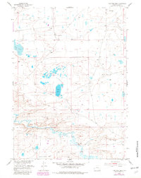
1955 Map of Pine Tree Ridge
USGS Topo · Published 1956About this map
Soda Lakes and the larger Soda Lake dominate this central Wyoming landscape, an area defined by alkaline basins and intermittent water. In the southern portion of the quadrangle, the terrain transitions into the namesake Pine Tree Ridge, overlooking the winding courses of Sevenmile Creek and Rock Creek. These waterways provide a stark contrast to the drier northern basins, such as Dry Lake and Mud Springs.
Find a feature on this map
12 named features on this map. Tap any name to fly to it.
Don’t see what you’re looking for? This feature index may not catch every label — zoom into the map to look around manually.
Map Details
Editions of this 1955 Pine Tree Ridge Map
2 editions found
Other maps of this area

1915 · Como Ridge
USGS Topo · 1:48,000

1918 · Como Ridge
USGS Topo · 1:62,500

1954 · Torrington
USGS Topo · 1:250,000

1954 · Cheyenne
USGS Topo · 1:250,000

1954 · Rawlins
USGS Topo · 1:250,000

1955 · Sevenmile Spring
USGS Topo · 1:24,000

1955 · Cannonball Cut
USGS Topo · 1:24,000

1955 · Wilcox
USGS Topo · 1:24,000

1955 · Casper
USGS Topo · 1:250,000

1958 · Rawlins
USGS Topo · 1:250,000