
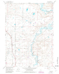
1955 Map of Wilcox
USGS Topo · Published 1957About this map
The settlement of Wilcox stands as a rail-side waypoint along the Union Pacific tracks in this mid-century portrait of Albany County. This high-plains landscape is defined by the vital movement of water and transit, where the meandering course of Rock Creek is paralleled by an intricate network of irrigation channels including Bosler Ditch No 3, Taylor Ditch, and Johnston Ditch. The infrastructure for heavy transit is prominent, with the Lincoln Highway and Garrett Road cutting across the terrain, while an Old RR Grade in the northeast corner hints at earlier routes through the basin. Local landmarks like the Historical Monument and a Landing Field with its associated Hangar suggest the area's significance beyond mere grazing land, while Pine Tree Ridge provides the primary topographic relief in an otherwise expansive corridor of plains and pipelines.
Find a feature on this map
21 named features on this map. Tap any name to fly to it.
Don’t see what you’re looking for? This feature index may not catch every label — zoom into the map to look around manually.
Map Details
Editions of this 1955 Wilcox Map
2 editions found
Other maps of this area

1915 · Como Ridge
USGS Topo · 1:48,000

1918 · Como Ridge
USGS Topo · 1:62,500

1954 · Cheyenne
USGS Topo · 1:250,000

1954 · Rawlins
USGS Topo · 1:250,000

1955 · Pine Tree Ridge
USGS Topo · 1:24,000

1955 · Sevenmile Spring
USGS Topo · 1:24,000

1955 · Cooper Lake North
USGS Topo · 1:24,000

1955 · Rock River
USGS Topo · 1:24,000

1955 · Cannonball Cut
USGS Topo · 1:24,000

1958 · Rawlins
USGS Topo · 1:250,000