
1955 Map of Cooper Lake North
USGS Topo · Published 1957About this map
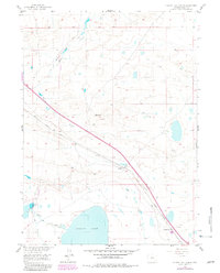
Cooper Lake dominates the southern reaches of this Albany County landscape, its northern shoreline defined by a Spillway and the irrigation infrastructure of Homer Ditch. The map documents a critical transportation corridor in the mid-1950s, where the Union Pacific Railroad and the Lincoln Highway run parallel through the high plains. The small station of Cooper Lake and the nearby terrain of Lookout mark significant points along this historic thoroughfare. These routes cut across the drainage of Meiser Creek and Dutton Creek, following a path that evolved from the Old Grade seen nearby. This survey, part of the Missouri River Basin development program, provides a technical view of the region's water management and transit network before further modernization changed the character of these high-altitude ranching and rail lands.
Find a feature on this map
11 named features on this map. Tap any name to fly to it.
Don’t see what you’re looking for? This feature index may not catch every label — zoom into the map to look around manually.
Map Details
Editions of this 1955 Cooper Lake North Map
2 editions found
Other maps of this area

1954 · Cheyenne
USGS Topo · 1:250,000

1955 · Bosler
USGS Topo · 1:24,000

1955 · Big Judson
USGS Topo · 1:24,000

1955 · Mc Gill Lakes
USGS Topo · 1:24,000

1955 · Cooper Lake South
USGS Topo · 1:24,000

1955 · Lake Ione
USGS Topo · 1:24,000

1955 · Rock River
USGS Topo · 1:24,000

1955 · Cannonball Cut
USGS Topo · 1:24,000

1955 · Wilcox
USGS Topo · 1:24,000

1958 · Cheyenne
USGS Topo · 1:250,000