
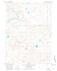
1955 Map of Cannonball Cut
USGS Topo · Published 1957About this map
The settlement of Rock Creek (Aband) sits as a quiet landmark on the western edge of this 1950s Wyoming landscape, illustrating a transition from early pioneer routes to industrial extraction. The area is defined by its historic transportation corridors, including the Old Fort Fetterman Road and the stark line of the Old Railroad Grade cutting across the central plains. These routes once serviced the high plains before shifting towards mineral development, evidenced by the Bentonite Pits found near the railroad. Water management is critical in this environment, shown through the Taylor Flume Ditch and Johnston Ditch that redirect the flow of the meandering Rock Creek. To the east, the terrain rises toward Chalk Bluff, while the southern reaches of the quadrangle feature Meiser Creek and the named point of Cannonball Cut.
Find a feature on this map
16 named features on this map. Tap any name to fly to it.
Don’t see what you’re looking for? This feature index may not catch every label — zoom into the map to look around manually.
Map Details
Editions of this 1955 Cannonball Cut Map
2 editions found
Other maps of this area

1954 · Cheyenne
USGS Topo · 1:250,000

1955 · Pine Tree Ridge
USGS Topo · 1:24,000

1955 · Mc Gill Lakes
USGS Topo · 1:24,000

1955 · Sevenmile Spring
USGS Topo · 1:24,000

1955 · Ayres Spring
USGS Topo · 1:24,000

1955 · Cooper Lake North
USGS Topo · 1:24,000

1955 · Lake Ione
USGS Topo · 1:24,000

1955 · Rock River
USGS Topo · 1:24,000

1955 · Wilcox
USGS Topo · 1:24,000

1958 · Cheyenne
USGS Topo · 1:250,000