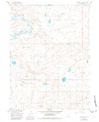
1955 Map of Cannonball Cut
USGS Topo · Published 1982About this map
Rock Creek (Aband) sits as a silent remnant of earlier settlement along the winding banks of Rock Creek in Albany County. The landscape is marked by the passage of frontier travel and early industry, defined by the path of the Old Fort Fetterman Road and the remnants of an Old Railroad Grade. A small Cem near the abandoned townsite offers a point of interest for genealogists tracing early families in this part of Wyoming.
Find a feature on this map
22 named features on this map. Tap any name to fly to it.
Don’t see what you’re looking for? This feature index may not catch every label — zoom into the map to look around manually.
Map Details
Editions of this 1955 Cannonball Cut Map
2 editions found
Other maps of this area

1954 · Cheyenne
USGS Topo · 1:250,000

1955 · Pine Tree Ridge
USGS Topo · 1:24,000

1955 · Mc Gill Lakes
USGS Topo · 1:24,000

1955 · Sevenmile Spring
USGS Topo · 1:24,000

1955 · Ayres Spring
USGS Topo · 1:24,000

1955 · Cooper Lake North
USGS Topo · 1:24,000

1955 · Lake Ione
USGS Topo · 1:24,000

1955 · Rock River
USGS Topo · 1:24,000

1955 · Cannonball Cut
USGS Topo · 1:24,000

1955 · Wilcox
USGS Topo · 1:24,000