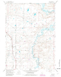
1955 Map of Wilcox
USGS Topo · Published 1982About this map
Union Pacific rail operations and an extensive network of irrigation ditches define this high-plains landscape in Albany County. The settlement of Wilcox serves as a focal point along the tracks, near where a Historical Monument is situated. The mapping reveals a sophisticated water management system designed for the arid environment, featuring the Bosler Ditch No 3, Taylor Ditch, and several other unnamed ditch segments that crisscross the terrain to divert water from Rock Creek.
Find a feature on this map
16 named features on this map. Tap any name to fly to it.
Don’t see what you’re looking for? This feature index may not catch every label — zoom into the map to look around manually.
Map Details
Editions of this 1955 Wilcox Map
2 editions found
Other maps of this area

1915 · Como Ridge
USGS Topo · 1:48,000

1918 · Como Ridge
USGS Topo · 1:62,500

1954 · Cheyenne
USGS Topo · 1:250,000

1954 · Rawlins
USGS Topo · 1:250,000

1955 · Pine Tree Ridge
USGS Topo · 1:24,000

1955 · Sevenmile Spring
USGS Topo · 1:24,000

1955 · Cooper Lake North
USGS Topo · 1:24,000

1955 · Rock River
USGS Topo · 1:24,000

1955 · Cannonball Cut
USGS Topo · 1:24,000

1955 · Wilcox
USGS Topo · 1:24,000