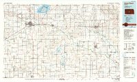
1985 Map of Great Bend
USGS Topo · Published 1990About this map
Cheyenne Bottoms and its namesake Cheyenne Bottoms State Wildlife Area dominate the northern landscape of this Central Kansas region. The Arkansas River snakes diagonally across the territory, anchoring a series of river towns from Pawnee Rock and Great Bend through Ellinwood, Sterling, and Nickerson. This 1980s landscape reveals a highly developed agricultural and energy-producing grid, where extensive Oil Field labels and numerous Gravel Pits are interspersed among established townships. The intersection of the Atchison Topeka and Santa Fe and Missouri Pacific railroads highlights the historical importance of the rail network in moving goods from the Quivira National Wildlife Refuge and the surrounding prairie. Smaller settlements like Seward, Hudson, and Chase provide critical points of reference for genealogists tracing local families in the Barton and Stafford county areas.
Find a feature on this map
105 named features on this map. Tap any name to fly to it.
Don’t see what you’re looking for? This feature index may not catch every label — zoom into the map to look around manually.
Map Details
Editions of this 1985 Great Bend Map
2 editions found
Other maps of this area

1889 · Cheney
USGS Topo · 1:125,000

1889 · Larned
USGS Topo · 1:125,000

1889 · Kinsley
USGS Topo · 1:125,000

1891 · Great Bend
USGS Topo · 1:125,000

1891 · Larned
USGS Topo · 1:125,000

1891 · Hutchinson
USGS Topo · 1:125,000

1891 · Cheney
USGS Topo · 1:125,000

1892 · Kinsley
USGS Topo · 1:125,000

1892 · Salina
USGS Topo · 1:125,000

1892 · Kingman
USGS Topo · 1:125,000